Categories
KWTO News

Significant Severe Weather, Including Tornadoes, Possible in the Ozarks Monday

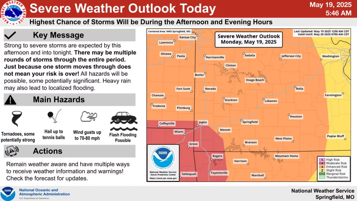
Potentially significant severe weather will impact the Ozarks Monday and Monday night, with a widespread area that could get multiple rounds of severe storms.

The National Weather Service says all hazards are possible, including tornadoes.

Some strong tornadoes are possible in areas south of a line from Joplin to Monett, where a level 4 out of 5 “moderate risk” is in effect.

Hail up to the size of tennis balls and damaging winds of 70 to 80 miles per hour are possible.

In addition to severe weather, flooding is a concern in the Ozarks, with a Flood Watch in effect from Monday afternoon through Tuesday morning.

Multiple rounds of showers and storms will result in many areas getting 1 to 3 inches of additional rainfall, with localized areas seeing up to 4 to 6 inches.

Get the latest graphics on tornado, hail and damaging wind probabilities, along with flooding, from the National Weather Service here.

Categories
KWTO News

Arrest Made In Homicide Near Shell Knob

The Stone County Sherrif’s Office has made an arrest in a homicide investigation.

Stone County Sheriff Doug Rader says deputies were called to a report of a man’s body near a road off Highway H near Shell Knob.

The 44-year-old man lived near close by.

The investigation is still ongoing.

Categories
KWTO News

Two Dead in Shooting at Mobile Home Park

The Greene County Sheriff’s Department is investigating an apparent fatal shooting in a mobile home park.

Deputies responded early Saturday morning to a report of gunshots in a trailer in the Lakewood Mobile Home Park.

Deputies found two men dead inside the trailer.

A person of interest was arrested but released.

No charges have been filed.

No names are being released until families are notified.

Categories
Hero

More Severe Storms Possible in the Ozarks Sunday and Especially on Monday

After a quiet Saturday, with some non severe thunderstorms rolling through the Ozarks late Saturday night, stay weather aware for both Sunday and Monday.

Click here for the latest severe weather packet from the National Weather Service in Springfield, including graphics on severe storm threats, timing, and flooding concerns.

The National Weather Service says showers and thunderstorms may develop and lift north along a warm front through the course of Sunday.

These have a low (5-15%) chance of becoming severe.

Later Sunday evening into the nighttime hours, storms moving in from Kansas and Oklahoma will present a greater severe risk.

However, details on exact storm mode and locations are still uncertain.

Strong to severe thunderstorms are possible again Monday and Monday night, and as with Sunday, forecasters say the greater severe risk exists during the evening and overnight hours.

But the weather service cannot rule out severe storms during the day Monday.

A moderate (level 4 of 5) risk may be issued for portions of the area in future updates, but most of the state is currently under a level 3 enhanced risk for severe weather on Monday.

Hazards will depend on storm mode and evolution, with increasing confidence in a line of storms Monday night.

We’ll have all the watches and warnings and storm updates on 93-3 and A-M 560 KWTO.

Categories
KWTO News

More Severe Storms Possible in the Ozarks Sunday and Especially on Monday

After a quiet Saturday, with some non severe thunderstorms rolling through the Ozarks late Saturday night, stay weather aware for both Sunday and Monday.

Click here for the latest severe weather packet from the National Weather Service in Springfield, including graphics on severe storm threats, timing, and flooding concerns.

The National Weather Service says showers and thunderstorms may develop and lift north along a warm front through the course of Sunday.

These have a low (5-15%) chance of becoming severe.

Later Sunday evening into the nighttime hours, storms moving in from Kansas and Oklahoma will present a greater severe risk.

However, details on exact storm mode and locations are still uncertain.

Strong to severe thunderstorms are possible again Monday and Monday night, and as with Sunday, forecasters say the greater severe risk exists during the evening and overnight hours.

But the weather service cannot rule out severe storms during the day Monday.

A moderate (level 4 of 5) risk may be issued for portions of the area in future updates, but most of the state is currently under a level 3 enhanced risk for severe weather on Monday.

Hazards will depend on storm mode and evolution, with increasing confidence in a line of storms Monday night.

We’ll have all the watches and warnings and storm updates on 93-3 and A-M 560 KWTO.

Categories
Hero

Body of Boy Recovered From Table Rock Lake

The body of a 12-year-old boy has been recovered from Table Rock Lake.

The Central Crossing Fire Protection District announced the body was recovered around 9 PM Friday night.

The boy was seen struggling and then went under the water at the Missouri 39 bridge, near Shell Knob, around 1 PM and did not resurface.

First responders from Barry County 9-1-1, Mercy E-M-S, the Barry County Sheriffs Department, the Highway Patrol, and Southern Stone County Fire Protections all helped with the search.     

Categories
KWTO News

Body of Boy Recovered From Table Rock Lake

The body of a 12-year-old boy has been recovered from Table Rock Lake.

The Central Crossing Fire Protection District announced the body was recovered around 9 PM Friday night.

The boy was seen struggling and then went under the water at the Missouri 39 bridge, near Shell Knob, around 1 PM and did not resurface.

First responders from Barry County 9-1-1, Mercy E-M-S, the Barry County Sheriffs Department, the Highway Patrol, and Southern Stone County Fire Protections all helped with the search.     

Categories
Hero

Baseball Size Hail, 70 Mile per Hour Winds and Tornadoes Possible in the Ozarks Friday

Large hail up to the size of baseballs, along with a chance of wind gusts up to 70 miles per hour and an isolated tornado: Much of the Ozarks is under at least some threat for severe weather on Friday.

The National Weather Service says scattered thunderstorms that are expected to develop Friday morning will move quickly from west to east between 10am and 3pm.

Additional storms are expected over the eastern Ozarks later in the day.

Areas east of Springfield are under a Level 3 “enhanced risk” for severe weather, with the far eastern Ozarks and southeast Missouri under a rare Level 4 “moderate risk.”

In the moderate risk area, hail up to softball size, wind gusts up to 80 miles per hour and a few tornadoes are all possible.

Additional strong to severe thunderstorms are possible at times through the weekend all the way through Tuesday of next week.

We’ll keep you up to date with watches, warnings and storm reports on 93-3 and A-M 560 KWTO.

Click here for the National Weather Service’s packet outlining Friday’s severe weather threats with graphics, confidence details and remaining uncertainties, along with severe weather chances through early next week.

Categories
KWTO News

Marionville Crash Leaves One Dead, Two Hospitalized in Critical Condition

One person is dead and two people are hospitalized after a crash in Marionville.

The Aurora and Marionville Police Department says two S-U-V collided on U-S 60 at Highway 265 as one of the S-U-V pulled into traffic.

The one driver died at the scene.

A woman driving the other S-U-V and her son are hospitalized in critical condition.