Categories
KWTO News

Easter Sunday Storm Threat Wraps Up For the Ozarks

Severe thunderstorms bringing damaging winds, hail, and tornadoes moved into the Ozarks from Kansas and Oklahoma by early Sunday afternoon, and by 6:30pm, had moved into south central Missouri.

The National Weather Service issued numerous severe thunderstorm and tornado warnings for communities in southwest Missouri.

One of the areas where the weather service believes a tornado touched down early Sunday afternoon is Lamar in Barton County.

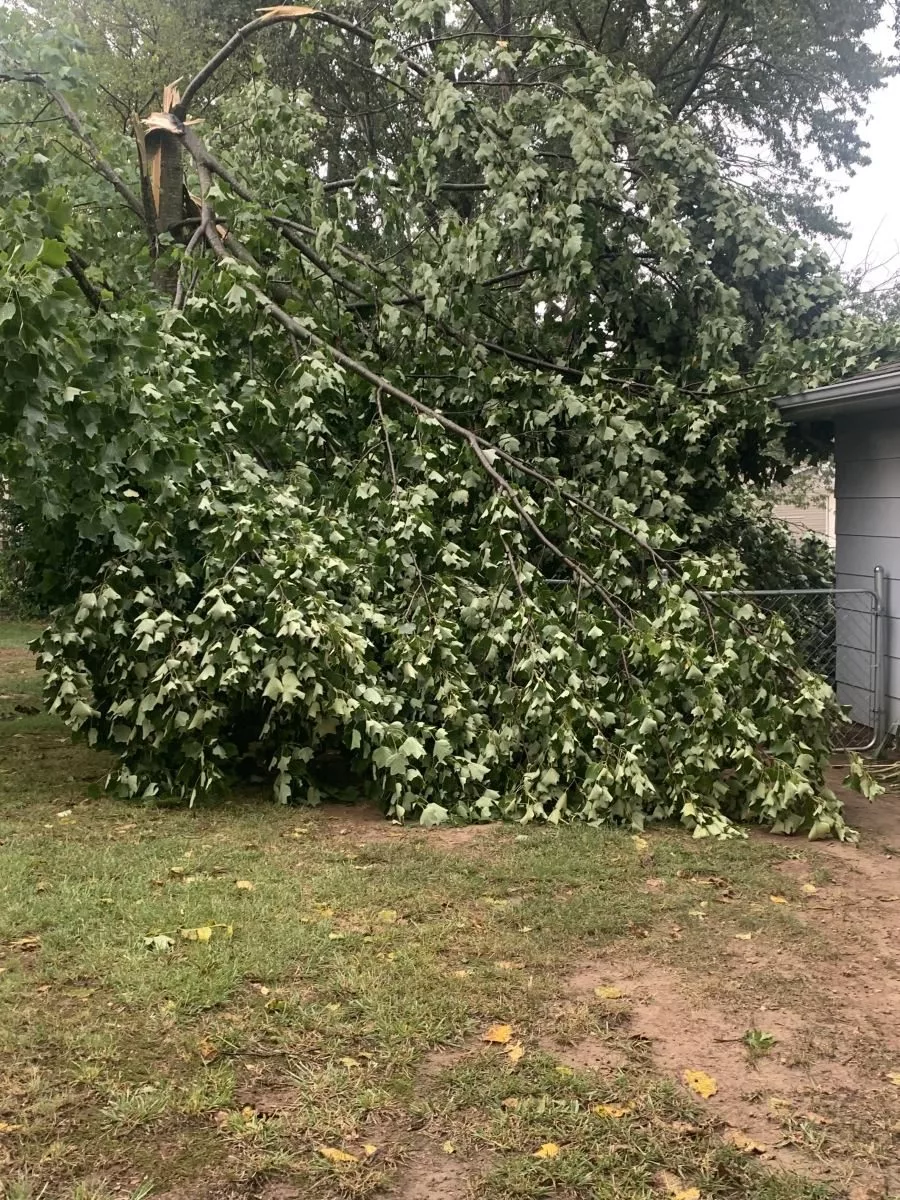
We’ve had reports of trees and powerlines down in Lamar. Emergency Management had reported the power is out in town, with damage extending to the northeast of town from a possible tornado.

Powerlines are down and a tornado siren was blown down near Lamar, with a barn destroyed and multiple power lines down along Highway J and County Road 126.

Here are other reports of damage that have come in from local emergency managers, the National Weather Service, local law enforcement and spotters.

Emergency Management reporting Street flooding and some powerlines down in Monett.

North of Stotts City (Lawrence County)—A tree is down south of Highway 96 on Highway 97.

Jasper County fire and law enforcement report several trees and power lines down and building damage in Carl Junction.

Street flooding, small tree debris, and some power lines down in Monett, according to Emergency Management

Reports of multiple trees down blocking Highway WW near Pennsboro in Dade County.

No power on the south side of Buffalo.

Jasper County 911 reporting a barn down west of Jasper, Missouri at Highway H and Highway O.

Power outage reported in Seymour.

Minor damage in southern Greene County, with an overturned livestock shed on east Farm Road 186, just east of Highway N-N. A Large MoDOT sign on west bound Highway 60 east of Highway J is snapped.

Trees down across the road southeast of Garrison in Christian County.

An 8 inch tree is down at Highway 160 and Highway 76 towards Taneyville.

Categories
KWTO News

M-S-U Mourns Death of Bears Football Player

Missouri State University is mourning the sudden death of senior football player Todric McGee.

He died Saturday morning at a Springfield hospital from injuries he sustained at his residence Friday.

He was 21-years-old. McGee was in his fifth season with the M-S-U Bears football team.

He earned all-conference honors in 2023.

The incident is under investigation. 

(Photo courtesy of Missouri State University Athletics) 

Categories
KWTO News

All Modes Of Severe Weather Possible in the Ozarks on Easter Sunday

Following a round of severe storms late Friday night that prompted both Tornado Warnings and Severe Thunderstorm Warnings in the Ozarks, more severe weather is on the way this Easter weekend.

The National Weather Service says the severe thunderstorm threat will ramp up again Saturday evening and overnight Sunday morning, with quarter size hail and damaging wind gusts being the primary threat, especially along and south of I-44.

The final round of severe weather this weekend, on Easter Sunday, is shaping up to be the most intense, with large hail up to golf ball size, damaging winds, and tornadoes all possible.

Timing is expected to be during the afternoon and evening hours on Sunday between noon and 8pm.

Most of the Ozarks is now under a Level 3 “Enhanced Risk” for severe weather on Sunday, with the exception of our far western counties along the Interstate 49 corridor, which are in a Level 2 “Slight Risk” area.

We’ll keep you up to date with all the watches and warnings and any damage reports on 93-3 and A-M 560 KWTO.

Categories
Hero

All Modes Of Severe Weather Possible in the Ozarks on Easter Sunday

Following a round of severe storms late Friday night that prompted both Tornado Warnings and Severe Thunderstorm Warnings in the Ozarks, more severe weather is on the way this Easter weekend.

The National Weather Service says the severe thunderstorm threat will ramp up again Saturday evening and overnight Sunday morning, with quarter size hail and damaging wind gusts being the primary threat, especially along and south of I-44.

The final round of severe weather this weekend, on Easter Sunday, is shaping up to be the most intense, with large hail up to golf ball size, damaging winds, and tornadoes all possible.

Timing is expected to be during the afternoon and evening hours on Sunday between noon and 8pm.

Most of the Ozarks is now under a Level 3 “Enhanced Risk” for severe weather on Sunday, with the exception of our far western counties along the Interstate 49 corridor, which are in a Level 2 “Slight Risk” area.

We’ll keep you up to date with all the watches and warnings and any damage reports on 93-3 and A-M 560 KWTO.

Categories
KWTO News

Latest on Severe Weather, Flooding Chances for Easter Weekend

Strong to severe thunderstorms are expected to move into the Ozarks by Friday night into Saturday morning, with additional chances for severe storms and flooding through the Easter weekend.

The National Weather Service says there is a Level 2 “Slight Risk” for severe storms Friday evening through Sunday, with the highest chances Friday evening into Saturday, with large hail and damaging winds the main threats.

Those storms are expected to develop across southeast Kansas and western Missouri after 5pm and continue through the overnight hours.

The most likely severe threats are large hail up to the size of quarters and damaging winds of 60 to 70 miles per hour.

In addition, several rounds of heavy rainfall will lead to some flash flooding and rises on area rivers this weekend.

A Flood Watch is in effect from 7pm Friday through 7pm Sunday for all of southwest Missouri.

Total rainfall amounts of 2 to 5 inches are likely across the entire area through the holiday weekend, with localized amounts up to 7 inches.

We’ll keep you up to date with the watches and warnings and any reports of damage on 93-3 and A-M 560 KWTO.

Categories
Hero

Latest on Severe Weather, Flooding Chances for Easter Weekend

Strong to severe thunderstorms are expected to move into the Ozarks by Friday night into Saturday morning, with additional chances for severe storms and flooding through the Easter weekend.

The National Weather Service says there is a Level 2 “Slight Risk” for severe storms Friday evening through Sunday, with the highest chances Friday evening into Saturday, with large hail and damaging winds the main threats.

Those storms are expected to develop across southeast Kansas and western Missouri after 5pm and continue through the overnight hours.

The most likely severe threats are large hail up to the size of quarters and damaging winds of 60 to 70 miles per hour.

In addition, several rounds of heavy rainfall will lead to some flash flooding and rises on area rivers this weekend.

A Flood Watch is in effect from 7pm Friday through 7pm Sunday for all of southwest Missouri.

Total rainfall amounts of 2 to 5 inches are likely across the entire area through the holiday weekend, with localized amounts up to 7 inches.

We’ll keep you up to date with the watches and warnings and any reports of damage on 93-3 and A-M 560 KWTO.

Categories
KWTO News

Man Arrested In Late 80s Springfield Cold Case

A man has been arrested in a Springfield cold case from the late 80s.

Springfield Police says advances in D-N-A testing has led to the arrest of 62-year-old Paul Bowles of Fulton in connection to the rape and murder of 18-year-old Jennifer Williams in Springfield in 1989.

Bowles was in the Fulton State Hospital when he was arrested.

He is in the Calloway County Jail for second degree murder, forcible rape and forcible sodomy.

Williams’ body was found in September of 1989 on West Chestnut by three juveniles.

Her husband had reported her missing a week earlier.

Categories
Hero

Severe & Wet Weather for Easter Weekend

It looks like we will have a wet and stormy Easter.

The National Weather Service says severe thunderstorms with large hail and damaging winds are on the way starting Friday night and lasting into Saturday morning.

Heavy rains are expected for Saturday and Sunday.

A Flash Flood Watch has been issued for Friday night through Sunday.

Categories
KWTO News

Severe & Wet Weather for Easter Weekend

It looks like we will have a wet and stormy Easter.

The National Weather Service says severe thunderstorms with large hail and damaging winds are on the way starting Friday night and lasting into Saturday morning.

Heavy rains are expected for Saturday and Sunday.

A Flash Flood Watch has been issued for Friday night through Sunday.