Categories
Hero

Flooding and Severe Storms Possible in the Ozarks Friday

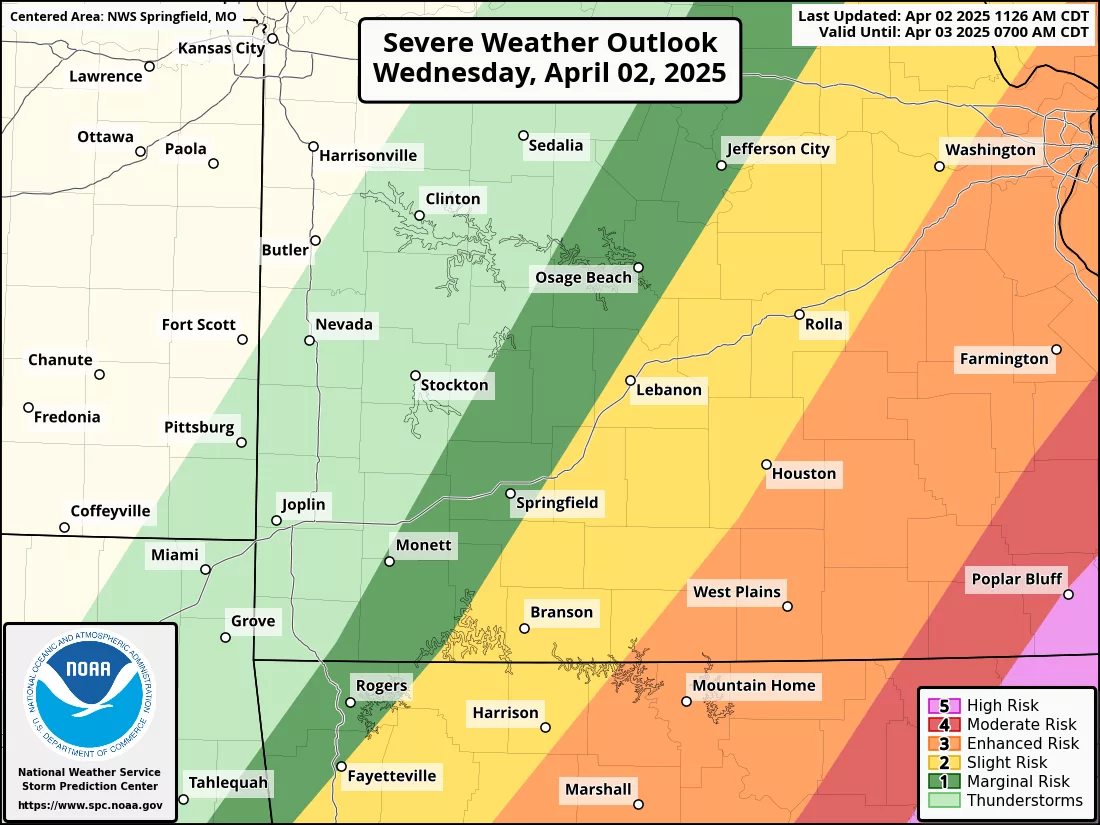
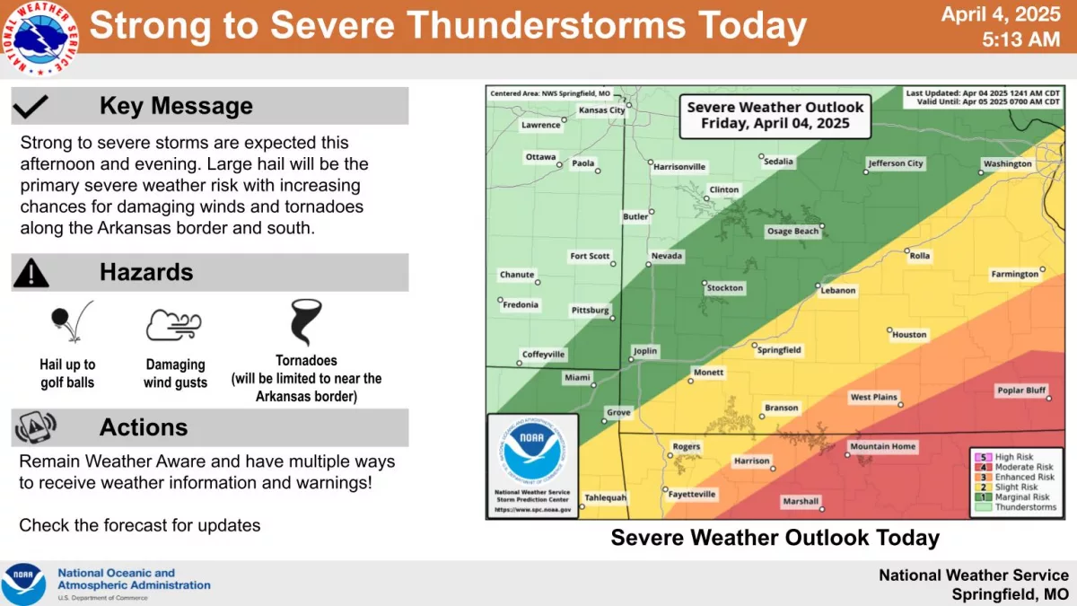
More severe thunderstorms are possible in the Ozarks on Friday.

The National Weather Service has issued a Severe Thunderstorm Watch for Greene, Christian, Jasper, Lawrence, Newton, Taney, Stone, Barry and McDonald Counties until 11:00am Friday.

Large hail and damaging wind gusts up to 70 miles per hour are the biggest threats with the morning activity, which is moving in from northern Arkansas and northeast Oklahoma.

All modes of severe weather, including tornadoes, are possible in northern Arkansas Friday, with some areas on the Missouri side of the border in line for severe thunderstorms.

Areas along a line from Harrison, Arkansas to West Plains are under a Level 3 “Enhanced Risk” for severe storms on Friday.

For the rest of the Ozarks, large hail will continue to be the biggest risk.

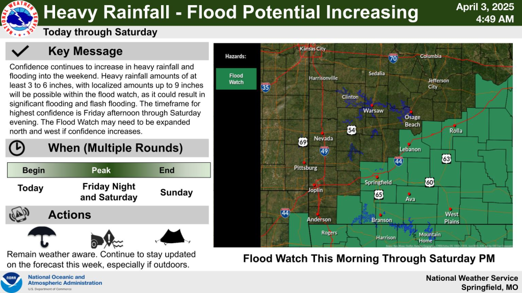
One of the biggest concerns forecasters have is flooding, with a Flash Flood Watch continuing for areas along and south of I-44 through Saturday evening.

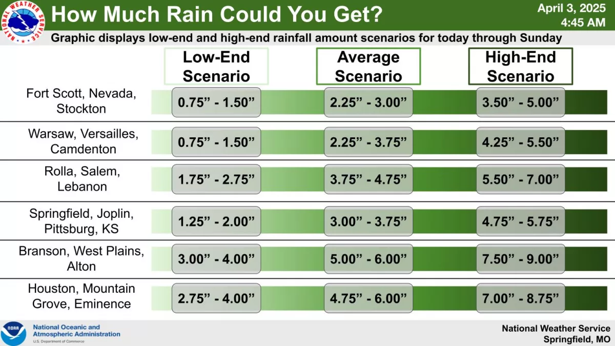
The National Weather Service says expected totals increase from northwest to southeast, ranging from around 2 inches to 8 plus inches.

Some localized areas could get 10 inches of rain, creating a serious flooding situation in south central Missouri.

Get the National Weather Service’s packet with graphics on severe weather and flooding expectations here.

Categories
KWTO News

Fatal Crash Closes Bridge at Lake of the Ozarks

A bridge at the Lake of the Ozarks had to be closed for three hours on Thursday after a fatal two-vehicle crash.

The Highway Patrol says a car driven by a 20-year-old Camdenton man crashed into the back of a pickup truck on the Old Toll Bridge on Highway M-M over the lake.

kari anne lake of the ozarks photo
Photo courtesy of KOLR/Nexstar.

The driver was taken to an area hospital where he died from his injuries.

Categories
KWTO News

Some Schools Closing Because of Flooding

The threat of heavy rainfall and flooding has caused some schools to cancel classes.

West Plains R-7, Koshkonong R-3, and Dora R-3 School Districts have cancelled classes for Friday.

Bakersfield, which was struck by a tornado last week, is giving parents and students the option to stay home.

The Bakersfield R-4 District says all absences Friday will be excused.

Categories
KWTO News

Aurora Woman Pleads Guilty to Murder

A woman from Aurora has pleaded guilty to first degree murder in the shooting death of her estranged husband.

Taylor Santiago also pleaded guilty to robbery, unlawful use of a weapon and endangering the welfare of a child. 

She’ll be sentenced on June 10th for the murder of Troy Huffman.

She’s also accused of shooting and wounding the father of her child and killing his girlfriend.

Categories
KWTO News

Suspect Arrested in Thursday Morning Shooting

Two people are in the hospital after a shooting near National and Kearney in Springfield early Thursday morning.

Police say their injuries are non-life threatening.

Police identified 21-year-old Dakota Nation as a suspect.

Nation was arrested after police surrounded his home.

He faces assault charges.

Categories
KWTO News

Heavy Rainfall and Flooding Concerns in the Ozarks

Thursday marks the beginning of persistent heavy rainfall in the Ozarks over the next several days, with a Flood Watch in effect for areas generally along and south of I-44 through Saturday evening.

Rain amounts of at least 3 to 6 inches, with locally higher totals up to 9 inches, are possible in portions of southwest Missouri.

The highest potential for flooding is Friday afternoon through Saturday evening.

We’ll keep you up to date with the latest forecast changes on 93-3 and A-M 560 KWTO.

image

Categories
Hero

Heavy Rainfall and Flooding Concerns in the Ozarks

Thursday marks the beginning of persistent heavy rainfall in the Ozarks over the next several days, with a Flood Watch in effect for areas generally along and south of I-44 through Saturday evening.

Rain amounts of at least 3 to 6 inches, with locally higher totals up to 9 inches, are possible in portions of southwest Missouri.

The highest potential for flooding is Friday afternoon through Saturday evening.

We’ll keep you up to date with the latest forecast changes on 93-3 and A-M 560 KWTO.

image

Categories
KWTO News

NWS Confirms EF-1 Tornado In Vernon County

The National Weather Service says an E-F-1 tornado touched down this morning in Venon County.

The tornado touched down around 7:30 AM in the town of Moundville passed through Nevada and ended in Walker.

Winds reached 98 miles per hour, uprooted trees and tore 8 train cars from a railroad track.

Categories
KWTO News

SGF Police Say Mother & Child Found Safe

A missing woman and her 10-month-old child have been located safe.

Cora Eastland had last been seen with her mother, Katlyn Darter, in Cabool on March 21st.

Darter had last been seen in Springfield on March 25th.

Police did not say where the mother and daughter were found.

Categories
KWTO News

Tornado Damage In Nevada: More Severe Storms Possible Wednesday Afternoon

The National Weather Service is confirming a tornado track from the south through the east side of Nevada Wednesday morning.

A Tornado Warning was in effect for Vernon County when the storm hit, flipping over multiple semi trucks on Interstate 49.

In addition, there were reports of roofs off of buildings and trees uprooted.

We had several tornado warnings west of Springfield Wednesday morning, with severe thunderstorm warnings in the metro area and other parts of the Ozarks.

The storms also knocked out power to parts of southwest Missouri, with Vernon County reporting nearly 4,600 outages during the peak of the storm.

Barton County reported around 400 outages.

In Springfield, storms knocked down a tree that damaged a power line near Oak Grove and Madison, but the line was quickly repaired by crews from Springfield City Utilities.

The Tornado Watch for much of southwest Missouri was allowed to expire at noon, but Ozark, Douglas and Wright Counties in the eastern Ozarks are under a Tornado Watch until 4pm Wednesday.

Forecasters say the best chance of tornadoes Wednesday afternoon and evening will be along and east of Highway 63, where strong tornadoes are possible.